Difference between revisions of "Document PIHM calibration"
(Set PropertyValue: TargetDate = 2016-03-31) |
|||
| (3 intermediate revisions by 2 users not shown) | |||
| Line 17: | Line 17: | ||
<!-- Do NOT Edit below this Line --> | <!-- Do NOT Edit below this Line --> | ||
{{#set: | {{#set: | ||
| + | Owner=Chris_Duffy| | ||
| + | Progress=70| | ||
StartDate=2014-11-01| | StartDate=2014-11-01| | ||
| − | |||
SubTask=Document_PIHM_calibration_as_an_on-line_service| | SubTask=Document_PIHM_calibration_as_an_on-line_service| | ||
SubTask=Document_PIHM_calibration_using_evolutionary_algorithms| | SubTask=Document_PIHM_calibration_using_evolutionary_algorithms| | ||
| − | Type= | + | SubTask=Document_PIHM_manual_calibration| |
| + | TargetDate=2016-03-31| | ||
| + | Type=Low}} | ||
Latest revision as of 13:59, 19 October 2015
Document PIHM calibration
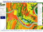
An important feature of PIHM is the utilization of geospatial data necessary to setup and run the model for a given watershed from national data sources. In simple terms, each dataset utilized in the modeling process is a geospatial map (vector or raster) with assigned properties. For example, SSURGO (USDA ref) is a national map for soil type in GIS format (see figure 1). Each soil delineated by the map is associated with a lookup table of soil texture (sand-silt-clay-bulk density-organic content) from which model hydraulic parameters are estimated. It is important to realize that the estimated parameters determined from the map, and then projected onto the numerical mesh, are considered a-priori initial guesses, and likely to have a high uncertainty. However, we have found that the most important thing about the soils data is the spatial map itself. A-priori parameters are only used as an initial guess and must be optimized as part of the model process as described below.

Our assumption is that the map geometry is reproducing reasonably unique patterns of different soil types even though the initial parameters assigned to each soil type may be much less certain. We have tested this assumption at the Shale Hills CZO and it has been shown to be a reasonable assumption. All parameters in PIHM are initially estimated from national data sets. The reader is referred to HydroTerre for the specific data sets in current use. Most of the parameters in a PIHM model can be optimized given sufficient field data and reasonable initial estimates (e.g. a-priori estimates from national geospatial data).
There are different approaches to calibrating the PIHM model:
- Automatic calibration. A sensitivity-based parameter estimation method known as Partition Calibration Strategy (PCS), which uses an evolutionary algorithm.
- Manual calibration.